Bertha Reaches Texas Coast, Weakens Near Galveston
Tropical Storm Bertha moved inland over eastern Texas on Thursday, July 23. Rain totals, the Texas coast warning zone, and Galveston surf hazards explained.

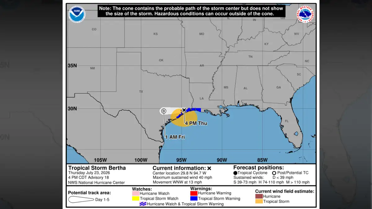
Tropical Storm Bertha moved inland over eastern Texas by 4:00 PM CDT Thursday, July 23, with its centre about 35 miles north of Galveston and maximum sustained winds of 40 mph, down from the 45 mph recorded earlier in the day, while the National Hurricane Center forecast the storm would dissipate by Thursday night or Friday.
What the Storm Looked Like as It Crossed the Coast
At 10:00 AM CDT, Bertha was still offshore, positioned roughly 100 miles east-northeast of Galveston, with 45 mph sustained winds moving westward at 10 mph. Within six hours it had crossed the coast, shed 5 mph off its peak winds, and was pushing inland on a west-northwest track at 13 mph. Minimum central pressure at the afternoon advisory stood at 1006 mb.
The storm produced limited wind and rain impacts across the Houston metro. The NWS Houston/Galveston forecast office described Bertha as increasingly disorganised as it moved into southeast Texas, with shower and thunderstorm activity sheared south of the circulation and displaced over the Gulf, limiting the rainfall footprint across the city.
The system first came ashore in Louisiana on Wednesday afternoon, in St. Bernard Parish near the Biloxi Wildlife Management Area, before tracking westward through the night toward the Upper Texas Coast.
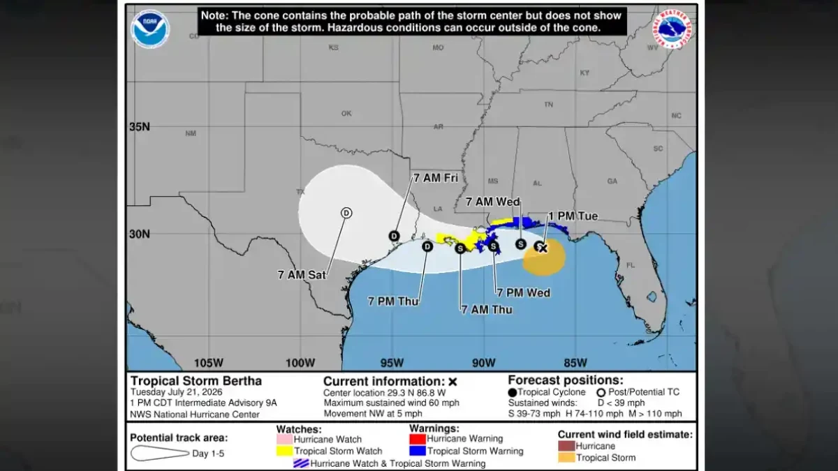
For context on Bertha's earlier strength during its Gulf crossing, when it carried 60 mph winds and triggered warnings across Florida and Louisiana, the storm's Gulf Coast path and earlier hazard breakdown details how rapidly the system lost intensity before reaching Texas.
Texas Coast Warning Zone and Timing
A Tropical Storm Warning was active across the Upper Texas Coast by Thursday morning. At 10:00 AM, NHC Advisory 17 showed the warning running from Morgan City, Louisiana, westward to Sargent, Texas. By the afternoon advisory, the eastern edge had been trimmed, the warning then extended from the Vermilion/Cameron Parish Line in Louisiana to Sargent, Texas, reflecting Bertha's westward progress and the reduced threat to areas it had already passed.
Galveston Island sat inside the core warning zone. The local NWS warning product for Galveston Island called for peak winds of 30 to 40 mph with gusts reaching 45 mph along the immediate coast. Tropical-storm-force winds extended outward up to 140 miles south of the centre by the afternoon advisory.
Conditions inland differed: mostly breezy, with scattered showers and isolated storms. The NWS Houston office estimated the stronger backside winds at around 20 to 30 mph with gusts of 35 to 40 mph on the storm's northern side. Coastal communities closer to the water faced the higher end of that range.
Rain Totals: Forecasts Came Down Through the Day
The rainfall picture shifted as Bertha weakened. At 10:00 AM, NHC guidance called for 2 to 4 inches across the Texas Gulf Coast and South Texas, with isolated totals up to 6 inches. By 4:00 PM, Advisory 18 revised that down to 1 to 3 inches, with isolated pockets reaching 4 inches.
Both advisories noted that isolated flash flooding remained possible, particularly in urban areas where drainage systems can be overwhelmed quickly. A widespread Houston flooding scenario, the kind that triggers major street closures and bayou overflows, was not what official data supported by Thursday afternoon. The displaced convection meant the heaviest rain stayed south and offshore for much of the day.
Galveston: Surf and Rip Currents the Clearest Danger
For coastal communities, rough water was the primary confirmed hazard. The NHC warned that Bertha-generated swells could produce life-threatening surf and rip-current conditions along the Texas coast. Elevated water levels were expected to persist through at least one additional high-tide cycle before subsiding.
Earlier Thursday, surge guidance indicated water levels could rise 1 to 2 feet above ground between Port Bolivar, Texas, and Port Fourchon, Louisiana, if peak surge aligned with high tide. The afternoon advisory shifted to language noting water levels could stay elevated through the next tidal cycle, still a genuine hazard for anyone near the shoreline or in low-lying coastal areas.
Galveston beaches saw rough surf develop through the afternoon. Anyone near the water on Galveston Island or the Bolivar Peninsula faced real rip-current risk well into Thursday evening.
When Effects Ease
The NHC forecast Bertha would dissipate by Thursday night or Friday, July 24. As the remnant circulation moves inland and loses its tropical characteristics, wind and rain effects taper. Coastal water conditions, elevated surf and rip-current risk, typically lag the storm itself by several hours and may persist into Friday morning even after the system has officially ceased to exist.
Anyone planning morning activities at Galveston or along the Upper Texas Coast on Friday should check the latest NWS Galveston marine and coastal forecast before heading out. Surf warnings can remain valid for hours after a storm's circulation has fully dissolved.
- tropical storm bertha texas coast
- bertha galveston surf warning
- tropical storm bertha 2026
- bertha houston impacts
- bertha texas landfall july 2026