Tropical Storm Bertha at 60 mph: Gulf Coast Path and Hazard Update
Tropical Storm Bertha carries 60 mph winds toward the northern Gulf Coast on July 21, with storm warnings stretching from Florida to Louisiana. Path, hazards, and preparation.

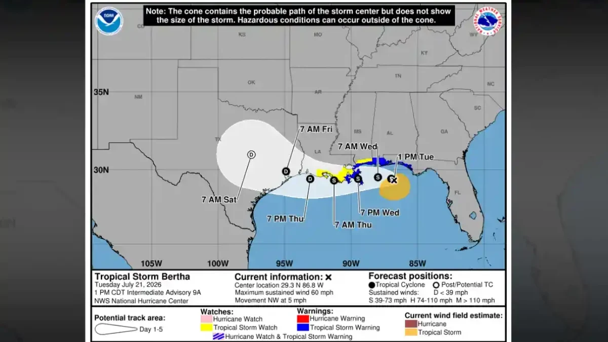
Air Force Hurricane Hunters confirmed Tuesday morning that Tropical Storm Bertha had strengthened to maximum sustained winds of 60 mph, positioned about 70 miles south-southwest of Panama City, Florida. Advisory Number 9 from the National Hurricane Center, issued at 10:00 AM CDT on July 21, 2026, placed the storm's center at 29.3°N, 86.3°W, about 145 miles southeast of Mobile, Alabama. A Tropical Storm Warning now covers a continuous stretch of northern Gulf coastline from the Bay/Gulf County Line in Florida westward to the Terrebonne/Lafourche Parish Line in Louisiana.
Bertha formed Monday evening as the second named storm of the 2026 Atlantic hurricane season, upgrading from a tropical depression with maximum sustained winds around 40 mph. The Air Force Hurricane Hunters' investigation, completed Tuesday morning, confirmed the storm had strengthened to 60 mph.
Where Bertha Is Headed
Moving north-northwest at just 3 mph at the time of the 10:00 AM advisory, Bertha's slow forward speed is the primary hazard driver for coastal residents: the NHC forecast discussion noted that a near-stationary tropical storm deposits more rain and sustains surge levels over the same sections of shoreline for an extended period.
The NHC forecast calls for Bertha to turn west-northwest and then due west later Tuesday into Tuesday night. Once that turn takes hold, the storm is expected to move near or along the northern Gulf Coast through the middle of the week before weakening progressively. The forecast track shows the center approaching the Louisiana coast by Wednesday night and continuing westward toward Southeast Texas as a gradually weakening system through Friday.
Tropical-storm-force winds currently extend outward up to 90 miles from Bertha's center. NOAA buoy 42039, south-southeast of Pensacola, recorded sustained winds of 49 mph with a gust to 54 mph Tuesday morning, the first surface instrument data confirming the storm's reach.
Warnings, Watches, and What Changed Tuesday
The 10:00 AM advisory brought significant changes to the warning and watch map. The NHC upgraded a Tropical Storm Watch to a full Tropical Storm Warning from the Florida-Alabama border eastward to the Bay/Gulf County Line. The warning was simultaneously extended westward to the Terrebonne/Lafourche Parish Line.
A Tropical Storm Watch, meaning conditions are possible within 24 to 48 hours, remains in effect west of that line all the way to the Vermilion/Cameron Parish Line in Louisiana, and separately covers Metropolitan New Orleans, Lake Pontchartrain, and Lake Maurepas.
The Storm Surge Watch that had been in effect along parts of the northern Gulf Coast was discontinued with this advisory package. In its place, the National Weather Service issued a Coastal Flood Warning for portions of the southeastern Louisiana and Mississippi coastline.
Storm Surge, Rain, and Surf Hazards
Coastal flooding is the most consequential immediate threat. According to the official NHC advisory, storm surge could raise water levels between 2 and 4 feet above ground along the stretch from the Mouth of the Mississippi River to the Mississippi-Alabama border. Surge of 1 to 3 feet is forecast for Lake Pontchartrain, the Vermilion/Cameron to Mississippi River zone in Louisiana, and sections of coastal Alabama and Florida, including Indian Pass to the Aucilla River.
The NHC expects 2 to 4 inches of rainfall across the central Gulf Coast from western Florida into southern Louisiana through Thursday, with isolated higher totals around 6 inches possible. Flash flooding is a concern, particularly in urban areas where drainage systems can struggle with fast-accumulating rain.
Swells generated by Bertha are already affecting parts of Florida's Gulf Coast and will spread westward during the week. The NHC flagged the potential for life-threatening surf and rip current conditions across Gulf beaches. Red flags were flying Tuesday at Orange Beach, Alabama.
Why Bertha Probably Won't Strengthen Further
Strong northeasterly vertical wind shear is working against the storm. The NHC forecast discussion noted that this shear, combined with land interaction as Bertha approaches the coast, should prevent significant strengthening and instead push the storm toward gradual weakening through midweek.
Bertha's structure is already asymmetric, the strongest winds and heaviest rainfall are concentrated to the south and east of the center rather than wrapping evenly around it. Convection is pulsing to the storm's south, and forecasters noted it remains possible that Bertha could degenerate into a disorganized trough even sooner than the official forecast suggests if its structure becomes more disrupted given the strong wind shear affecting the storm.
The extended forecast shows Bertha weakening to a tropical depression by late Thursday near the Southeast Texas coast and dissipating by July 26.
Preparation Along the Coast
Communities from Florida to Louisiana had moved into storm-readiness mode well ahead of Tuesday's conditions. Emergency officials in Escambia County, Florida, made sand available for residents in flood-prone areas to fill sandbags. In New Orleans, city authorities asked residents to complete storm preparations by Tuesday and to clear catch basins around their properties to help drainage systems cope with incoming rainfall.
The Louisiana Health Department issued guidance Monday urging residents to review emergency plans and stockpile supplies. Louisiana State University had begun monitoring Bertha when it was still a tropical depression, posting public updates on its social media channels and official weather page.
Bertha in the Broader 2026 Season
Bertha is the second named storm of the 2026 Atlantic season, following Tropical Storm Arthur, which brought heavy rain and flash flooding to parts of Louisiana, Texas, and Mississippi in June. NOAA issued its seasonal outlook in May, forecasting a below-normal season with 8 to 14 named storms, 3 to 6 hurricanes, and 1 to 3 major hurricanes. The agency placed a 55% probability on a below-normal season, driven primarily by El Niño conditions that tend to increase upper-level wind shear across the Atlantic basin.
Bertha at 60 mph sits well below the 74 mph threshold required for hurricane classification. The NHC forecast does not show a pathway to hurricane intensity given the strong wind shear affecting the storm throughout the forecast period.
The next complete advisory from the National Hurricane Center is scheduled for 4:00 PM CDT Tuesday.
- Tropical Storm Bertha
- Bertha Gulf Coast
- Bertha storm track
- Gulf Coast weather July 2026
- Bertha storm surge