Iowa Under Extreme Heat Warning as 110°F Index Looms
An Extreme Heat Warning now covers most of Iowa through Tuesday evening, with heat index values climbing toward 110°F as the wave spreads east across the U.S.

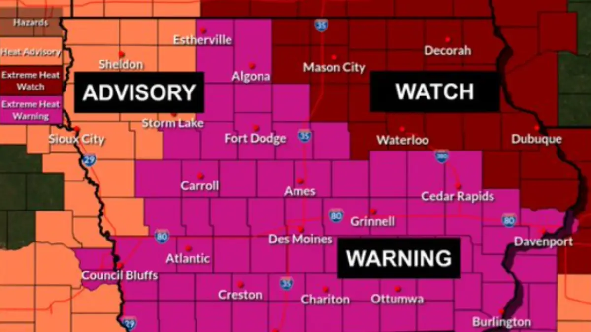
The National Weather Service office in Des Moines placed most of Iowa under an Extreme Heat Warning beginning at 1 p.m. Sunday, June 28, with heat index values forecast to reach as high as 110°F through Tuesday evening. Parts of northeastern Iowa remain under an Extreme Heat Watch rather than the warning, according to the office's overnight forecast discussion.
The warning marks an upgrade from the watch status that covered the state earlier in the weekend. Local broadcaster KCCI had reported most of Iowa under a watch through Tuesday, but the Des Moines forecast office moved the bulk of its coverage area to a warning as confidence in the dangerous heat increased.
What changed and why
Daily highs across Iowa are expected to reach the mid-to-upper 90s through the warning period, with overnight lows only falling into the 70s. That narrow overnight drop limits the body's ability to recover from daytime heat stress, the Des Moines office said in its forecast discussion.
The warning officially runs through 9 p.m. Tuesday, the period of highest forecaster confidence. Conditions are expected to stay hot and humid for most or all of the coming week, with forecasters watching the pattern carry into the July 4 weekend.
Northeast Iowa counties enter their alert period later than the rest of the state, with the watch there set to begin Monday afternoon and run through Tuesday evening.
The wider Midwest and East Coast picture
The Weather Prediction Center, a national forecasting arm of the NWS, described the broader event as a significant and dangerous heat wave spreading across the central and eastern United States into early July. Its extended forecast pointed to daily highs in the 90s to low 100s across a wide swath of the country, with heat index values around or above 105 to 110°F in many places.
Meteorologist Frank Pereira told USA TODAY that temperatures will run well above normal across much of the central and eastern U.S., with the most intense heat building into the middle of next week. He said records could begin falling from the Ohio Valley into the Mid-Atlantic and Northeast by June 30 and July 1, with triple-digit air temperatures reaching from the Carolinas north through Washington, D.C., by July 2.
A separate Northern Indiana forecast office, covering the Fort Wayne television market reached by WANE 15, issued its own Extreme Heat Watch running from Monday afternoon through Thursday evening. That watch allows for heat index values up to 105°F across northern Indiana, southwest Michigan and northwest Ohio. WANE 15 separately designated June 30 through July 2 as "15 Fury Alert Days," a station branding label that is not an official government alert category.
Region | Current alert | Heat index forecast | Alert window |
|---|---|---|---|
Most of Iowa | Extreme Heat Warning | Up to 110°F | Sunday 1 p.m. – Tuesday 9 p.m. |
North central and northeast Iowa | Extreme Heat Watch | Up to 109°F | Monday afternoon – Tuesday evening |
Northern Indiana / SW Michigan / NW Ohio | Extreme Heat Watch | Up to 105°F | Monday afternoon – Thursday evening |
Raleigh, North Carolina area | Dangerous heat expected | Upper 90s to triple digits | Continuing through Thursday, Friday |
The Climate Prediction Center's latest probabilistic outlook lists a moderate risk of extreme heat across much of the central and eastern United States on July 3 and 4, with a slight risk extending across the same general area from July 3 through July 6. An earlier version of that outlook had listed a higher-tier risk for the same period, but forecasters said that risk had shifted earlier into the holiday week as the pattern evolved.
A naming change worth knowing
The phrase "extreme high temperature warning" is not an official National Weather Service product. The agency's current term is Extreme Heat Warning. The NWS renamed its heat products in March 2025, retiring the older "Excessive Heat Watch" and "Excessive Heat Warning" labels in favor of "Extreme Heat Watch" and "Extreme Heat Warning."
That rename means older graphics, cached web pages or social posts using "Excessive Heat Watch" are now using a retired label rather than describing a different, lesser alert.
Heat illness: know the difference
Heat exhaustion can cause heavy sweating, weakness, cool or clammy skin, a fast and weak pulse, cramps, dizziness, nausea and headache. NWS guidance advises moving the person to a cooler place, loosening clothing, cooling them with damp cloths and offering small sips of water, then seeking medical care if symptoms worsen or last beyond an hour.
Heat stroke is different and more dangerous. Warning signs include confusion, slurred speech, a very high body temperature, hot and red skin, a rapid strong pulse and fainting. The NWS and the CDC's National Institute for Occupational Safety and Health both say to call 911 immediately if these signs appear, since delayed treatment can be fatal.
Children and pets should never be left unattended in vehicles during this stretch. Car interiors will reach lethal temperatures in a matter of minutes, according to current NWS alert language for the Northern Indiana region.
What happens next
The Des Moines warning is set to expire at 9 p.m. Tuesday, though forecasters expect the underlying hot, humid pattern to persist through the week. The Weather Prediction Center's extended outlook covers the period through July 4, with the Climate Prediction Center's risk assessment extending into the following weekend.
Readers in the affected regions should check the current alert status for their specific county before making outdoor plans, since watch and warning boundaries can shift as the week progresses.
- extreme heat watch
- extreme high temperature warning
- Extreme Heat Warning
- Iowa heat wave
- heat index
- July 4 heat wave