Earthquake in the Philippines Today: Death Toll Hits 65 After 7.8 Mindanao Quake
A powerful 7.8 earthquake hit southern Mindanao on June 8, killing 65 people and triggering tsunami warnings lifted that afternoon local time. Here's the full update.

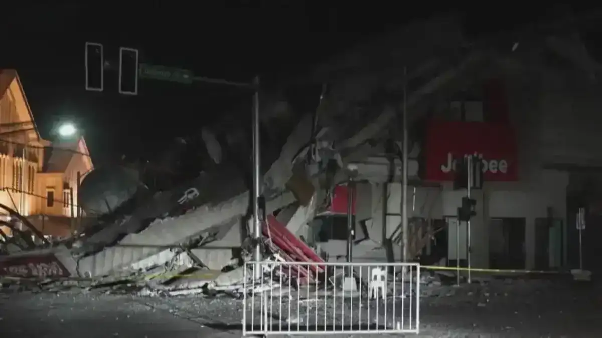
At 7:37 in the morning on June 8, 2026, a magnitude 7.8 earthquake tore through the seabed south of Maasim, Sarangani. Within minutes, sirens followed. Coastal communities across nine provinces were ordered to evacuate. Tsunami warnings stretched from Zamboanga to Davao Oriental. One week on, the full weight of what happened is still being tallied and the numbers keep climbing.
What Happened and Where
The earthquake struck with its epicenter about 32 km south of Maasim, Sarangani, at a depth of 33 km, according to DSWD's official DROMIC Report #14. PHIVOLCS confirmed the earthquake was caused by movement along the Cotabato Trench, according to the PHIVOLCS primer published the same day.
PHIVOLCS issued tsunami warnings almost immediately. Nine provinces in Mindanao were evacuated. The AHA Centre's Flash Update confirmed the warning, evacuation orders, and early situation reports. Specific wave heights were confirmed by PHIVOLCS Tsunami Information No. 2, as reported by GMA News. All tsunami warnings were lifted at 07:50 UTC on June 8 which corresponds to 3:50 p.m. Philippine Standard Time according to the JMA bulletin via GDACS, more than eight hours after the quake struck.
The highest recorded wave was 1.48 metres in Kiamba, with 0.84 m in Kalamansig and 0.48 m in Maasim itself. Only minor sea level disturbances were detected after an extended observation period, and the recorded wave heights were well below the threshold for major coastal flooding.
The earthquake has since generated more than 6,058 aftershocks as of June 15, 2026, according to News5 citing PHIVOLCS, including a significant 6.7-magnitude aftershock in the early days. By early June 9, the AHA Centre ADINet dashboard had already recorded 840 aftershocks, 240 plotted, and 19 felt.
The Human Cost: What the Numbers Tell Us
The latest update as of 7:00 a.m. Monday, June 15, from AHA Centre ADINet, paints a stark picture:
Category | Figure | Source |
|---|---|---|
Deaths | 65 | AHA Centre ADINet / OCD |
Missing | 36 | AHA Centre ADINet |
Injured | 1,447 | AHA Centre ADINet |
Affected persons | 736,386 | AHA Centre ADINet |
Internally displaced | 73,174 | AHA Centre ADINet |
Damaged houses | ~57,252–58,576 | AHA / DSWD DROMIC |
Roads affected | 135 | AHA Centre ADINet |
Bridges affected | 41 | AHA Centre ADINet |
Schools affected | 8,642 | DepEd / The Star |
The death toll had been reported at lower figures in early days 37, then 61 but the Office of Civil Defense confirmed to Philippine Inquirer that the count stood at 65 dead, 36 missing, and approximately 1,400 injured as of 6:00 a.m. on June 15. The AHA Centre's structured table records a slightly higher injury figure of 1,447. Note that DSWD DROMIC Report #14 lists a slightly different affected population figure 664,388 persons across 169,005 families compared to AHA ADINet's 736,386 persons, reflecting the timing differences between official agency updates.
Affected regions include DSWD's Region IX (Zamboanga Peninsula), Region XI (Davao), Region XII (Soccsksargen), and BARMM covering provinces from Sarangani and South Cotabato to Davao del Sur, Davao Oriental, Davao del Norte, Basilan, and Sultan Kudarat.
Infrastructure, Schools, and Power
The damage radius is wide. According to DSWD's official disaster report, more than 58,000 houses were damaged 11,302 completely destroyed, over 47,274 partially damaged. The official breakdown also shows 18,423 displaced people sheltered inside 44 evacuation centers, with a further 51,978 displaced outside, bringing the DSWD total to 70,401 displaced persons.
Over 8,600 schools across six regions and 43 divisions were hit, affecting millions of learners and education staff, according to reporting by The Star citing DepEd situational data. The Philippine National Police ramped up patrols in affected areas amid widespread power outages, with the National Electrification Administration working to restore electricity to 803,230 affected consumer connections, as reported by the Philippine News Agency citing NEA.
DSWD's relief operation had delivered over ₱124.9 million in humanitarian assistance with more than ₱5.1 billion in standby funds and stockpiles including nearly 4.83 million family food packs ready for distribution as documented in DSWD DROMIC Report #14.
The Coastline Changed Overnight
One of the more extraordinary and troubling findings from this earthquake is what happened to the shoreline.
The earthquake raised parts of the seabed by approximately 2 metres in coastal areas of Sarangani and Davao Occidental, according to a joint aerial survey on June 11 by PHIVOLCS and the Mines and Geosciences Bureau Region 12. In Barangay Pangyan, Glan, Sarangani, the shoreline retreated by approximately 200 metres as previously submerged seabed was pushed above the waterline. PHIVOLCS confirmed the uplift was caused by movement along the Cotabato Trench, according to Philstar and Philippine Inquirer citing the agency's official advisory.
The ecological consequence is already visible. Coral reefs and seagrass beds that were previously submerged are now exposed to open air, drying out and dying. The Department of Environment and Natural Resources Region 12 confirmed that exposed corals and seagrass beds had begun dying alongside their resident organisms reef fish, eels, clams, and shells and that the stench of decaying marine life had become a health concern for nearby residents. Scientists could not yet precisely determine the total area affected, as the rugged and extensive coastline still needed to be surveyed.
This type of coastal uplift where land along the coastline rises abruptly due to tectonic movement during a major earthquake is a significant geological event that can permanently alter coastal topography, shift tidal boundaries, and destroy marine habitats. As the GMA News explainer notes, the effects on coastal communities and ecosystems can persist long after the shaking stops.
The Bigger Picture
The Philippines sits at one of the most seismically active stretches of the Pacific Rim. Mindanao in particular has long been vulnerable to major earthquakes from the Cotabato Trench and the Philippine Fault System. PHIVOLCS notes that at least seven significant earthquakes with magnitudes ranging from M5.7 to M8.0 have affected Sarangani and nearby provinces between 1917 and 2023, with the last damaging earthquake in the vicinity being a Mw 6.8 event in November 2023.
Pope Leo XIV expressed his closeness to Filipinos affected by the earthquake during his Angelus address on June 14. "I assure the people of the Philippines, struck a few days ago by a powerful earthquake, of my closeness," the Pope said, according to Philstar's report of the official Vatican translation. "I pray for the deceased and their families, for the wounded and for all those suffering because of this disaster," he added.
For those tracking earthquake activity across the Philippines, HazardHunterPH provides an earthquake monitoring map based on the PHIVOLCS Philippine Seismic Network the official government platform for earthquake data and situational awareness.
Rescue and recovery efforts are ongoing. Tens of thousands of people remain displaced. For a region managing the complexity of multiple affected provinces, the work ahead is enormous and the aftershocks keep coming.
This earthquake in the Philippines is not a closed story. It's still being written, one aftershock at a time.
- earthquake in the philippines today
- philippines earthquake 2026
- mindanao earthquake
- tsunami warning philippines
- philippines earthquake map